Hello,
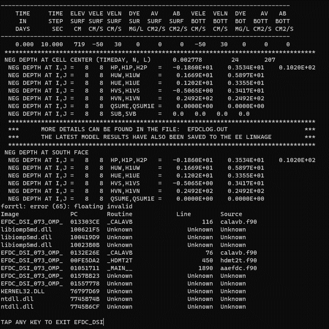
I encountered a problem relating to floating invalid error.
During the run of EFDC, It seems that the cell (8, 8) has negative depth at cell center and south face.
After finding error, I did change dry depth, wet depth and dry step. Also I changed Time step in Timing/Linkage Tab ( 1440sec → 60sec-> 10sec), but nothing changed.
Could you please help me to solve this issue?
And also I have another question to ask.
I have been simulating with the example file provided by EFDC, and now I want to simulate with my own destination.
The study site is the Paldang Lake watershed in South Korea. I couldn’t get bathymetry data, so I used np.linspace() in python numpy to add random values based on the elevation meter of the observatory. I would like to ask if it is okay to do what I did when I couldn’t get bathymetry data.
For the 1st question, the negative depth problem may caused by different reasons like the water level change suddenly, rough bottom, … Therefore, you should check all the conditions around that error cell like boundary, bottom roughness, bottom elevation, … instead of changing shallow water parameters and time step only. If you still cannot fix the issue after checking the conditions around that cell, plesae send us the model, then we can help you to check it.
For the 2nd question, you can totally do that, but if you put in a random value to the bathymetry, the model may be unstable and the output may different with the reality
The dry and wet depth you put in the model is too small, those values should be around 10-15cm
Both boundary conditions you put in the model are inflow, if you want to set an outflow, you should multiply the data with -1
The main reason caused the crash of the model is the water elevation IC you set in the model. The water depth at cells near River boundary is very shallow combine the water slope is really large (25m in 4km length) makes the model unstable. I have tried to change the WSEL IC to 6m for all cells and the model can run normally
Thank you for your thoughtful response.
Now I know what the problem is!
But there’s one more thing I’d like to ask you.
Regarding the IC, is it correct that Bathymetry Data means Bottom Elevation and WSEL Data means Water Level?
I looked up the EFDC example file and in dxdy.inp, Bathymetry Data is entered as Bottom Elevation, and when I added Depth to this value, it became WSEL Data.
I often get negative values for Bathymetry Data, what is this based on, is the reference zero elevation?
Thank you for your time.
Yes, they are bottom elevation & water surface elevation (or water level)
Basically, water depth = WSEL - bottom elevation. Therefore, even you added water depth or WSEL, they are all converted to WSEL and save to dxdy.inp file
The bottom elevation is based on the vertical datum. Each region will have different vertical datum which also known as zero-elevation surface. You can access this link for more details